Govejk - Sveti Tomaž (Vrsnik nad Žirmi)
Starting point: Govejk (710 m)
Starting point Lat/Lon: 46.0251°N 14.07°E 
Time of walking: 40 min
Difficulty: easy marked way
Difficulty of skiing: no data
Altitude difference: 34 m
Altitude difference (by path): 100 m
Map: Škofjeloško in Cerkljansko hribovje 1:50.000
Access to starting point:
A) From Železniki, Kranj or Medvode we drive to Škofja Loka, and from there we continue driving in the direction of Gorenja vas in Poljanska dolina and Žiri. In Žiri or at the end of Žiri (Stare Žiri), we leave the main road towards Rovte and Logatec and continue right in the direction of Idrija. After less than 4 km of driving from the junction in Žiri, we arrive at the settlement Govejk and a smaller saddle, where the road starts descending. On the mentioned saddle a road towards Ledine and Ledinske Krnice branches off to the right. We park in a suitable place by the junction.
B) From Horjul or Polhov Gradec we drive to Šentjošt above Horjul, and from there we continue driving towards Smrečje. When we reach the main road Podlipa - Žiri, we follow it to the right, and we drive along it to Žiri. When in Žiri we reach the main road Škofja Loka - Logatec, we follow it to the left, and we drive past the parish church and the inn and pizzeria Lenger. After the inn we arrive at a junction, where we leave the main road towards Logatec and continue driving in the direction of Idrija. After less than 4 km of driving from the junction in Žiri, we arrive at the settlement Govejk and a smaller saddle, where the road starts descending. On the mentioned saddle a road towards Ledine and Ledinske Krnice branches off to the right. We park in a suitable place by the junction.
C) From the motorway Ljubljana - Koper we take the Vrhnika exit, then when we reach the old road Ljubljana - Logatec, we continue in the direction of Logatec, but only for a short time, as already at the next junction we continue right in the direction of Horjul. The road ahead leads through Vrhnika for a short time, later through the outskirts of Stara Vrhnika, then soon we leave the road towards Horjul and continue driving slightly left in the direction of Smrečje. After Smrečje the road starts descending towards Račeva and Žiri. When in Žiri we reach the main road Škofja Loka - Logatec, we follow it to the left, and we drive past the parish church and the inn and pizzeria Lenger. After the inn we arrive at a junction, where we leave the main road towards Logatec and continue driving in the direction of Idrija. After less than 4 km of driving from the junction in Žiri, we arrive at the settlement Govejk and a smaller saddle, where the road starts descending. On the mentioned saddle a road towards Ledine and Ledinske Krnice branches off to the right. We park in a suitable place by the junction.
D) From the motorway Koper - Ljubljana we take the Logatec exit, and when we reach the old road Logatec - Vrhnika we follow it to the right (first exit from the roundabout), along which we drive only for a short time, as then the signs for Rovte and Žiri direct us left. After Rovte the road starts descending towards Žiri, and when we reach the mentioned place, we soon turn left in the direction of Idrija. After less than 4 km of driving from the junction in Žiri, we arrive at the settlement Govejk and a smaller saddle, where the road starts descending. On the mentioned saddle a road towards Ledine and Ledinske Krnice branches off to the right. We park in a suitable place by the junction.
E) From the road Idrija - Spodnja Idrija, immediately after the end of Idrija we turn right (if coming from the direction of Spodnja Idrija, we turn left even before Idrija) over the bridge across the river Idrijca towards the Eurospin store. On the other side of the bridge we arrive at the settlement Mokraška vas, and we stick to the main road leading towards Ledinsko Razpotje and Žiri. Higher up the road takes us through a few hairpin bends, then we arrive at the settlement Ledinsko Razpotje, about 2 km further on to the settlement Govejk. We park in a suitable place by the smaller saddle, where the road to Ledine and Ledinske Krnice branches off to the left.
Path description:
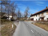
From the starting point we continue for a short time on the main road towards Ledinsko Razpotje, then we continue left in the direction of the settlement Vrsnik. The path ahead leads us in a gentle ascent along the asphalted local road, from which some views open up on the surrounding hills. Higher the road flattens, and at the smaller junction we continue slightly left on the marked road. Further on the right we already see the church of St. Tomaž, and on the marked road we walk for a few more minutes, or to the spot where the road splits into two parts. Slightly left runs the marked road which leads further towards Žiri, and we continue slightly right on the unmarked road, which gradually turns even more to the right. At the first junction we continue sharply left and somewhat downhill, then a little further at the chapel right onto the macadam road, which starts ascending through increasingly panoramic hay meadows. At the smaller junction, which we reach on the section where the increasingly poor road flattens somewhat, we continue slightly right and continue the path along the cart track, along which in two or three minutes of further walking we arrive at the church of St. Tomaž, from which a nice view opens up on the surrounding hills.
Description and pictures refer to the condition in 2015 (January).
On the way: Gornji Vrsnik (715m)
Pictures:
 1
1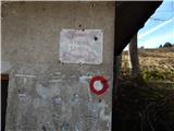 2
2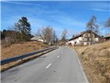 3
3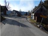 4
4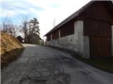 5
5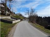 6
6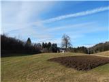 7
7 8
8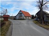 9
9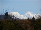 10
10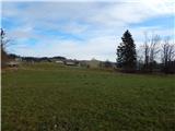 11
11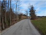 12
12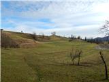 13
13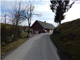 14
14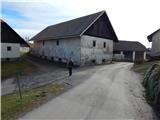 15
15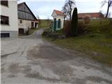 16
16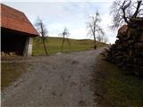 17
17 18
18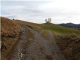 19
19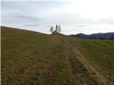 20
20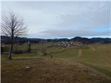 21
21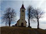 22
22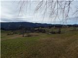 23
23