Ribniška koča - Koča na Pesku (via Lovrenška jezera)
Starting point: Ribniška koča (1507 m)
Starting point Lat/Lon: 46.4974°N 15.2555°E 
Path name: via Lovrenška jezera
Time of walking: 3 h 25 min
Difficulty: easy marked way
Difficulty of skiing: easily
Altitude difference: -121 m
Altitude difference (by path): 300 m
Map: Pohorje 1:50.000
Access to starting point:
A) From the road Maribor - Dravograd, before the settlement Brezno we turn left in the direction of Podvelka, Ribnica na Pohorju and Ribniška koča. After the bridge over the river Drava we get to Podvelka, and the road further we follow in the direction of Ribnica na Pohorju. After approximately 10 km from the bridge over Drava we get to the center of Ribnica na Pohorju, where we go left. Next follows approximately 8 km of ascent, mostly on the macadam road, to the mountain hut Ribniška koča, where we park.
B) From Dravograd we drive towards Maribor, after Radlje ob Dravi at the roundabout we leave the main road towards Maribor and we continue driving in the direction towards Vuhred, Ribnica na Pohorju and Ribniška koča. After the bridge over the river Drava we get to Vuhred, and the road further we follow in the direction of Ribnica na Pohorju. After approximately 10 km from the bridge over Drava we get to the center of Ribnica na Pohorju, where we go right. Next follows approximately 8 km of ascent, mostly on the macadam road, to the mountain hut Ribniška koča, where we park.
Path description:
From Ribniška koča we go on the path in the direction of Jezerski vrh and lake Ribniško jezero and we at first walk on the road, on which we came to the starting point and in a gentle descent leads to the saddle between Mali Črni vrh and Jezerski vrh. On the saddle, where it is also possible to park we leave the road and go on a marked footpath which at first gently and then steeply ascends to the monument on Jezerski vrh, which we reach in approximately 10 minutes of more and more panoramic ascent.
From Jezerski vrh we continue slightly left in the direction of lakes Lovrenška jezera and Rogla (left - Ribniško jezero 5 minutes) and we start descending through a thin forest. Soon from the left joins the path which leads past the lake Ribniško jezero, and we continue with at first a still moderate descent through a thin forest and then we pass into a dense forest, and the path is descending a little steeper. During the descent a short path branches off to the left towards the memorial of pilots, and we continue the descent to the saddle Šiklarica. After the saddle we again start ascending, and at few smaller crossings we follow the blazes. A little further, we go past a well, and after the well we are few minutes quite steeply ascending. Higher, the path flattens and it brings us out of the forest on the meadow Planinka, through which we are mostly gently to moderately ascending with increasingly beautiful views. Higher, the path turns right and only a little further from the left joins the path from Lovrenc na Pohorju. Follows some more of the crossing with nice views, and then the path passes into a thin forest, where it runs below plateau of lakes Lovrenška jezera, and consequently we cross a larger number of smaller streams. After few minutes of crossing, we get to a marked crossing, where we continue left in the direction of Lovrenška jezera and Rogla (slightly right - Rogla the path which bypasses Lovrenška jezera) and we start ascending on a wooden pavement. After few minutes of the ascent, we join the eastern path from Rogla, and we go left and we quickly get to a lookout tower at lakes Lovrenška jezera.
From the tower a nice view opens up towards the plateau, where there are located lakes, and from the tower we continue on a wooden pavement, which among dwarf pines take us to the lakes.
From the lakes we return to the last crossing and we continue in the direction of Rogla and Koča na Pesku.
Next follows a descent through partly thin forest, where we at first mostly walk on a wooden pavement, and lower on a cart track which with some shorter ascents and descents crosses slopes towards the left. During the crossing the path leads us also past some streams, and at the gentle part we get to a marked crossing, from which we continue left downwards in the direction of Koča na Pesku (straight - Rogla).
Next follows a descent on a cart track, through an again thinner forest, and when the path flattens, we over a small bridge cross the nearby stream. The path ahead leads us by the artificial lake intended for snowmaking on the ski slope Rogla, and a little further we reach a wider macadam road which we follow in a moderate ascent all the way to few minutes distant mountain hut Koča na Pesku.
Ribniška koča - Jezerski vrh 0:15, Jezerski vrh - Lovrenška jezera 1:50, Lovrenška jezera - Koča na Pesku 1:20.
Pictures:
 1
1 2
2 3
3 4
4 5
5 6
6 7
7 8
8 9
9 10
10 11
11 12
12 13
13 14
14 15
15 16
16 17
17 18
18 19
19 20
20 21
21 22
22 23
23 24
24 25
25 26
26 27
27 28
28 29
29 30
30 31
31 32
32 33
33 34
34 35
35 36
36 37
37 38
38 39
39 40
40 41
41 42
42 43
43 44
44 45
45 46
46 47
47 48
48 49
49 50
50 51
51 52
52 53
53 54
54 55
55 56
5657
 58
58 59
59 60
60 61
61 62
62 63
63 64
64 65
65 66
66 67
67 68
68 69
69 70
70 71
71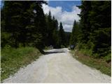 72
72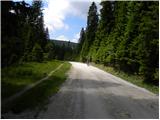 73
73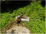 74
74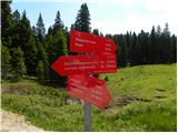 75
75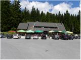 76
76