Central entrance into NP Paklenica - Vaganski vrh (Ramići - Buljma)
Starting point: Central entrance into NP Paklenica (90 m)
Path name: Ramići - Buljma
Time of walking: 6 h 30 min
Difficulty: easy marked way
Difficulty of skiing: no data
Altitude difference: 1667 m
Altitude difference (by path): 1725 m
Map: Paklenica, 1:25.000, l.2011, 50 kun
Access to starting point:
After the Maslenički most bridge we turn off the highway, which continues towards Dalmatia. Look for the sign for Starigrad Paklenica (approx. 7-8 km from the highway). In this settlement, find and follow the brown signs with the inscription NP VELIKA Paklenica (not the first one, that is Mala Paklenica). The road leads to the asphalt parking lot. Entrance to NP Paklenica is paid, last time it cost 40 kun per person, the car is probably included in this price, because we two didn't pay for it separately. You are at 90 m above sea level! Surprisingly high, we'd say!
Path description:
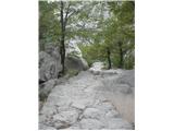
Start is at the NP Paklenica parking lot, the path ahead is stone-paved and rises in serpentines. We walk under the climbing areas the whole time. This part of the path is simply called Klanci. We arrive at a path junction, where one continues towards the Planinski dom Paklenica mountain hut, the other turns right to the famous climbing wall Anića kuk. We need less than an hour to get here.
From the junction onward, we follow the path and signs to Planinski dom Paklenica. On the way, it is possible to detour to the Manita peć cave, which is another 45 minutes from the path. We continue to the hut. Quite possibly, a mule-donkey might surprise you on the way, which the hut keeper leads down to the valley for food and supplies and then loaded back to the hut! The hut is at 480 m altitude, but my husband and I got the feeling upon arrival that it was more of a "private" affair, so we continued to the Ramići, 5 minutes walk away. It was worth it! From the Ramići, a classic mountain path leads onward. After ten minutes, we spot three signs for three possible routes. One is Lipa staza - it is direct, steep, runs in serpentines, first a bit through the forest, then on scree/gravel, and in summer not very recommended for ascent. You can also choose between two others, namely Bukova staza, which in the upper part passes by the so-called Babino jezero, and the third, Lipi brig, which reaches the plateau and viewpoint Buljma at 1394 m and Bivak Struge at 1410 m. This is the path we chose. The path leads through forest, first moderately, then increasingly steeply ascending. On the way there are some side paths and shortcuts, but the markings are reliable. The section of the Lipi brig trail toward Buljma called Perina greda was demined. Our path meets the one coming from Velika Gospa and V. Golić and from Buljma. Krajni brig is the junction of these paths. Geographically, this part is called Brezimenjača. A steeper ascent is noticeable already before, from here the serpentines continue, which in summer heat can be quite annoying. Moreover, a mountain biker cannot be ruled out! I must warn that on this described path there is NO water, so take enough for a seven-hour tour - one way! The elevation difference here is the same as going from Vrata to Triglav up and back in one day! Well-prepared mountaineer = satisfied mountaineer!
Buljma is a plateau-like area, but also the first concrete point from which, if not too foggy, a nice wide view of the coast and surrounding peaks opens up for the first time. This is a very nice spot for rest and snack. From Buljma onward, the path goes past Bivak Struge, which we bypassed, around Marasova gora to Marasovac, which is supposed to be a water spring, but it's almost impossible to get due to the hot and dry summer. The path then turns around Marasova gora and starts ascending again. We need to climb another approx. 300 elevation meters from 1400 m to 1700 m height. In one and a half hours we reach the fork where the path from Babino jezero arrives, which is about 15 minutes from the fork. From here we see our goal for the first time. It is still about an hour's walk away. From 1700 m we descend to contour 1634 m, which is a small pass, from it we climb one more hill, descend down, and in a couple of turns finally ascend to 1757.5 m (this is the contour from the map!) - Vaganski vrh! On the summit a cross and nice view greet us.
We descended via Lipa staza, the steep one I described at the beginning. We descend along the ridge toward the southeast, following the markings and signs, which are excellent all the way. First a short ascent awaits us, then, just when we thought we were finally rid of it, a fairly quick descent follows, which will be a pleasure especially for those who like running on scree. The lower part of the scree is already partly in the forest, so the scorching sun will be somewhat softened by shade. The path comes out at those three signs I described at the beginning as route directions to Vaganski vrh. From there we have another 10 minutes to well-deserved refreshment at the Ramići's and less than two hours of moderate walking to the parking lot. So, technically speaking, the tour is EASY, but due to its length very strenuous, also because you have to carry all food and drink with you. In any case, start very early, before dawn - e.g. 4:30, to avoid the worst heat before the summit. We had 35 degrees in mid-September. And we wish you many beautiful experiences!
On the way: Anića kuk (711m),
Vaganski vrh (1757m), Babin vrh (1738m), Buljma (1394m), Ramići (520m), Babino jezero (1520m)
Pictures:
 1
1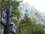 2
2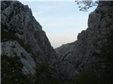 3
3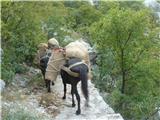 4
4 5
5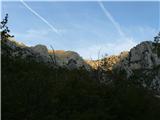 6
6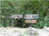 7
7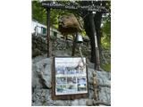 8
8 9
9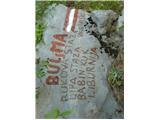 10
10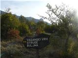 11
11 12
12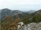 13
13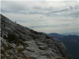 14
14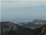 15
15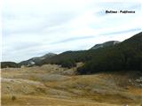 16
16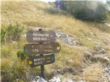 17
17 18
18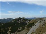 19
19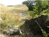 20
20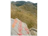 21
21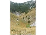 22
22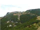 23
23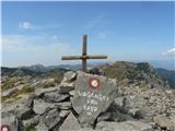 24
24 25
25 26
26 27
27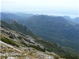 28
28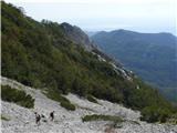 29
29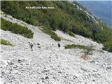 30
30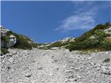 31
31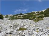 32
32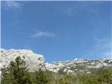 33
33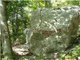 34
34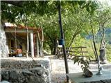 35
35 36
36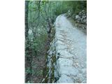 37
37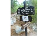 38
38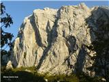 39
39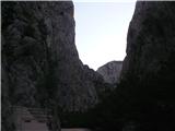 40
40