Dom na Osankarici - Veliki Šumik waterfall (via Črno jezero)
Starting point: Dom na Osankarici (1193 m)
Starting point Lat/Lon: 46.449°N 15.4196°E 
Path name: via Črno jezero
Time of walking: 1 h 55 min
Difficulty: difficult marked way
Difficulty of skiing: no data
Altitude difference: -243 m
Altitude difference (by path): 100 m
Map: Pohorje 1:50.000
Access to starting point:
A) We drive to Oplotnica (to here from the Štajerska motorway exit Slovenske Konjice or Slovenska Bistrica - south), then we follow the signs for Osankarica. After approximately 12 km of ascent from the center of Oplotnica we arrive at the parking lot near Dom na Osankarici.
B) First, we drive to Lovrenc na Pohorju (to here from the road Maribor - Dravograd), then we continue driving towards Rogla and Koča na Pesku. From Koča na Pesku we follow the signs for Osankarica, where we park on the parking lot below Dom na Osankarici. From the center of Lovrenc na Pohorju to the starting point there is approximately 26 km of mostly macadam road.
Path description:
From the parking lot, we head onto the marked path in the direction of Črno jezero. At first, we ascend the stairs, then we ascend along the paved wooden path. Higher, the path flattens and then descends a little along the still paved path to Črno jezero.
We continue for a short time beside the lake, then the path splits.
We continue left in the direction of Sv. Trije kralji (slightly right Oplotnica - path past Kos) and then mostly moderately ascend through the forest. Higher, we reach the indistinct northern ridge of Veliki vrh, where there is a marked junction.
We continue left in the direction of the Šumik waterfall and Ruš (right Sv. Trije kralji).
We continue on a gentle path through the forest, which leads us across Peščena ravna; after the indistinct peak Trije studenci the path gradually starts to descend. A little lower the forest thins, the path, which temporarily stops descending, has several junctions where we follow the blazes. After a shorter gentle ascent we start descending again and lower reach the macadam road which leads from Areh towards Osankarica, which we only cross and continue the descent to the next road, which we follow to the left (right Ruška koča na Arehu), along which we quickly arrive at the trailhead Bajgot na Šumiku, where to the right downward one of the paths to Ruš branches off (Holcarska pot through the Lobnica valley).
We continue in the mentioned direction, along which there are also signs for the Mali and Veliki Šumik waterfalls (straight posestvo Šumik, Koča na Klopnem vrhu...).
The path ahead starts to descend lightly along Lobnica, soon we arrive at a warning that the path ahead is very steep and slippery. A little further, we cross Lobnica over the footbridge, then descend along the right bank of Lobnica, where we gradually move onto steeper slopes. Further, pegs and steel cables help us at the difficult spots, a little lower with the aid of safety gear we descend over a short wall. Even below the wall the slope is quite steep and dangerous for slipping, descending mainly without safety gear.
A little lower we arrive at the spot where the stamp is located, then along the secured path we descend to the viewpoint at the Veliki Šumik waterfall.
Pictures:
 1
1 2
2 3
3 4
4 5
5 6
6 7
7 8
8 9
9 10
10 11
11 12
12 13
13 14
14 15
15 16
16 17
17 18
18 19
19 20
20 21
21 22
22 23
23 24
24 25
25 26
26 27
27 28
28 29
29 30
30 31
31 32
32 33
33 34
34 35
35 36
36 37
37 38
38 39
39 40
40 41
41 42
42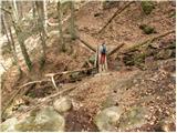 43
43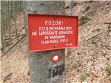 44
44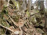 45
45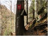 46
46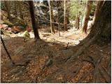 47
47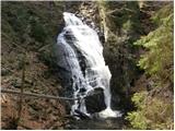 48
48