Ljubelj - Begunjščica (via Šentanski plaz, snowy approach)
Starting point: Ljubelj (1058 m)
| Latitude/Longitude: | 46,43240°N 14,26020°E |
| |
Route name: via Šentanski plaz, snowy approach
Walking time: 2 h 45 min
Difficulty: difficult pathless terrain
Elevation gain: 1002 m
Elevation difference along the route: 1002 m
Map: Karavanke - osrednji del 1:50.000
Recommended equipment (summer): helmet
Recommended equipment (winter): helmet, ice axe, crampons
Views: 39.691
 | 4 people like this post |
Access to starting point:
From the Ljubljana–Jesenice highway, we take the Ljubelj exit and follow the road ahead to the border crossing. Just a few tens of meters before the Ljubelj tunnel, signs for Zelenica direct us to the left and after a few tens of meters of additional driving, the road brings us to the parking lot below the former ski center Zelenica.
Route description:
From the parking lot, we head up the former groomed ski slope towards Zelenica, or we can take the parallel marked footpath (cart track) that runs through the forest. After approximately 15 minutes, both paths join, and we continue the ascent below the scree of Begunjska Vrtača. A little further ahead, the path splits again, and we continue straight towards the Koča Vrtača mountain hut (or also right on the transport-rescue road, which higher up joins the path past the mentioned hut (the latter path is more exposed to snow avalanches than the one past the hut)).
When we arrive at the Koča Vrtača mountain hut, the less steep part of the path is behind us, ahead of us lies the steepness of the former steep ski slope. At the top of the slope break, the previously mentioned service path joins us from the right, and at this point we leave the path leading towards Zelenica and continue the ascent left up the Šentanski plaz. This is followed by a steep ascent of approximately 500 elevation meters, then we choose the right exit onto the ridge (slightly left approach towards Begunjska Vrtača), where the steepness of the plaz becomes even somewhat greater. In the last part, the ascent can be made difficult by insufficient snow, which the wind blows away, or the last part may be icy, or both. When there is a lot of snow, the passage can also be hindered by huge cornices, which are especially dangerous in warm weather, when they can detach and fly down the plaz.
When we step onto the ridge, we reach the marked path from Prevala, but this is usually under snow in wintertime, though orientation further on presents no difficulties, as we follow the ridge the whole time, or walk slightly left of the scenic ridge. A few minutes higher, we reach the forepeak, from which Veliki vrh is already nicely visible in the ridge of Begunjščica, just a few minutes' ascent away.
The described path is exposed to avalanches, especially in the upper part also to slips.
The description and pictures refer to conditions in 2017 (February).

Photos:
 1
1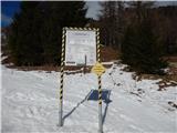 2
2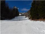 3
3 4
4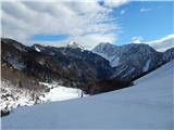 5
5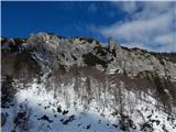 6
6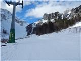 7
7 8
8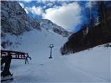 9
9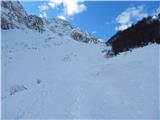 10
10 11
11 12
12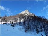 13
13 14
14 15
15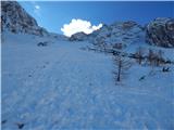 16
16 17
17 18
18 19
19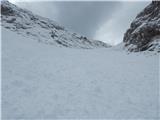 20
20 21
21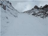 22
22 23
23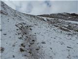 24
24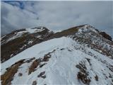 25
25 26
26 27
27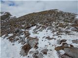 28
28 29
29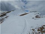 30
30 31
31 32
32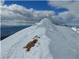 33
33 34
34 35
35 36
36 37
37 38
38 39
39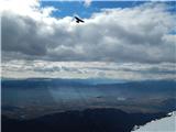 40
40
Discussion about the trip Ljubelj - Begunjščica (via Šentanski plaz, snowy approach)
|
| Gost26. 02. 2007 |
what equipment is necessary for sm up there?
|
|
|
|
| Gost26. 02. 2007 |
In favorable conditions you don't need anything. Otherwise in hard snow at least an ice axe. Crampons are needed only if it's icy. A helmet is part of the equipment that is not necessarily needed but in spring, when the snow melts, there is quite a lot of falling rocks, which mostly fly below head height. Rudi
|
|
|
|
| Gost27. 02. 2007 |
All equipment for winter hiking in the mountains. We all know that having equipment with you is mandatory (personal safety), what we will need we see on the spot. Therefore it's not true that in favorable conditions we don't need anything. In favorable conditions we go to the mountains at all, in unfavorable ones responsible mountaineers (again personal safety, rescuers' safety) prefer safe paths. I wish you a safe path!
|
|
|
|
| fpetel129. 11. 2008 |
With a colleague, we went yesterday, 28.11., over the avalanche chute. At the top it was windblown and somewhat icy, below it was sinking up to the rocks. It was blowing strongly at the top. If there is no avalanche danger due to new snow, recommended trail.
|
|
|
|
| Leon8115. 09. 2009 |
Is this path passable also in summer? Is there any climbing or just scree? I'm thinking of using it for descent instead of the marked path via the hut at Zelenica.
Best, Leon
|
|
|
|
| nata2415. 09. 2009 |
You just descend on scree and reach the hut at Vratača. No climbing at all.
Best, Nataša
|
|
|
|
| matejd25. 07. 2010 |
Today I went up but went too far to the south and started climbing the wrong scree...  so it got a bit complicated for me and I had to stow the poles and use my hands quite a bit ...but slowly and thoughtfully it was great. At the top all the effort is rewarded with views of the surrounding areas and mountains.... highly recommend even if you choose the easier approach. LP. so it got a bit complicated for me and I had to stow the poles and use my hands quite a bit ...but slowly and thoughtfully it was great. At the top all the effort is rewarded with views of the surrounding areas and mountains.... highly recommend even if you choose the easier approach. LP.
|
|
|
|
| martinza9. 03. 2012 |
Does anyone know what the conditions are like now? I plan to go up tomorrow. Thanks.
|
|
|
|
| sodnick10. 03. 2012 |
I join the question. Maybe there will be an answer sooner
|
|
|
|
| JakaM10. 03. 2012 |
The last 50 m below the top of the avalanche slope is snow-free, the rest is hard snow.
|
|
|
|
| sodnick17. 03. 2012 |
Have the conditions changed in the last week? Last week I didn't make it, we plan to go tomorrow.
|
|
|
|
| sodnick18. 03. 2012 |
Today on Begunjščica. Snow a bit mixed, quite hard in places, very soft in others. Ideal conditions for descending. Going up is a bit strenuous when it sinks to the ground at times. The last part of the gully is otherwise dry. It was very foggy and windy though. We had quite a bit of trouble with orientation, since it was our first time both. Suunto Core with compass and altimeter played its role
|
|
|
|
| benson16. 12. 2013 |
What are the conditions like these days?
|
|
|
|
| benson16. 12. 2013 |
*What are the
*conditions?

|
|
|
|
| garmont16. 12. 2013 |
In the lower part there is firm snow, but a track is made. Roughly 50 meters below the summit there is windblown snow and little of it.
But therefore more rocks. Crampons are necessary for that part. Crampons are necessary for that part.
|
|
|
|
| ločanka7. 04. 2014 |
Today, when I was returning from Zelenice, an avalanche released on Šentanski plaz, its start was from the right direction and it scared a couple of skiers and us few hikers. We were returning along the track towards the middle station of the cable car.
I assume that a cornice broke off due to water-soaked snow. It's not pleasant when compacted snow balls with a diameter of 1 m or more fly past you at maximum speed. I'll say, the early bird catches the worm. This time it was around 1 pm.
|
|
|
|
| ljubitelj gora7. 04. 2014 |
At such temperatures, one doesn't go into any gully, Šentanski plaz is no exception.
|
|
|
|
| Potohodnik1. 05. 2014 |
Today I was heading to Šentanski plaz. Snow starts at koča Vrtača. Before that just small patches of snow. It was 10:15 when two rocks broke loose, one large about a meter, the other half smaller. Rocks fly at quite high speed. I'll write an article on my blog and post the link here.
|
|
|
|
| marjanmo14. 02. 2017 |
On Sunday, 12.2. I found a hiking pole in the snow in the middle of Šentanski plaz, whoever misses it, let me know.
|
|
|
|
| jazo131224. 03. 2019 |
Today exceptional! Warm and no wind.
See the video.
VLOG
Regards, Jan
|
|
|
|
| ssimon15. 01. 2022 12:22:16 |
Thanks for the info.
|
|
|
To post a comment you must log in:
If you do not yet have a username, you must first
register.