Zalog - Planica (Paragliding site Gozd)
Starting point: Zalog (535 m)
Starting point Lat/Lon: 46.3253°N 14.3535°E 
Time of walking: 1 h 30 min
Difficulty: easy marked way
Difficulty of skiing: no data
Altitude difference: 391 m
Altitude difference (by path): 391 m
Map: Karavanke - osrednji del 1:50.000
Access to starting point:
A) We leave the Gorenjska motorway at the Kranj west exit, then follow the signs for Golnik. In the settlement Goriče we leave the main road towards Golnik and continue right towards Zalog. Further on, we follow the signs for Zalog, where in the centre of the settlement, by the mountain signposts, the described path begins. At the starting point there are no arranged parking spaces.
B) From Tržič we drive to Križe, then continue towards Golnik and Kranj. In the settlement Goriče we leave the main road towards Kranj and continue left towards Zalog. Further on, we follow the signs for Zalog, where in the centre of the settlement, by the mountain signposts, the described path begins. At the starting point there are no arranged parking spaces.
Path description:
From the centre of Zalog we continue straight in the direction towards Gozd and Kriška gora (right Velika Poljana, Mala Poljana and Storžič) and along the asphalt road we continue to the hamlet Svarje, where the road turns left. The road becomes macadam after a few houses, and we leave it before it starts to descend.
We continue right, where behind the house the path enters the forest, and in the forest markings also appear, which until now, except for the mountain directional sign, had not been there. Through the forest we first ascend transversely to the left, and when we reach the cart track, we continue right. The cart track soon branches, we choose the left one, and at the following junctions we follow the markings. Higher up the cart track ends and we continue the ascent along an initially still steep mountain path, which gradually flattens. The flat path leads us out of the forest onto expansive pastures, across which we walk in a few minutes to the village Gozd, where at the first junction we continue left (right Koča na Kriški gori and Tolsti vrh), at the second junction, only a few dozen steps away, we go right (left Golnik).
The path ahead leads us past the little church of St. Nicholas, past the parking lot and past the junction of the road towards the Gozd take-off site, to the shelter Zavetišče v Gozdu, which we notice on the left side of the road.
From the shelter we return a few dozen steps back, then continue in the direction of the viewpoint and Gozd take-off site. First we ascend along the asphalt road, from which a beautiful view opens towards Kriška gora, the road soon becomes macadam and enters the forest. Only a slight ascent follows and the path brings us to Planica i.e. the Gozd take-off site.
Description and pictures refer to the condition in 2018 (September and October).
Pictures:
 1
1 2
2 3
3 4
4 5
5 6
6 7
7 8
8 9
9 10
10 11
11 12
12 13
13 14
14 15
15 16
16 17
17 18
18 19
19 20
20 21
21 22
22 23
23 24
24 25
25 26
26 27
27 28
28 29
29 30
30 31
31 32
32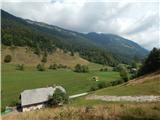 33
33 34
34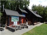 35
35 36
36